Clipping Volume
Clipping Volume
Clipping Volumes define present volumes of space used for timely filtering of any data for visualization purposes. These plans are usually based on the working levels within a mine, however, the limits can be anything the user desires.
Any table containing the following columns can be used to define the Clipping Volumes:
- ID Number, for each Clipping Volume
- A descriptive name field to define the clipping volume (e.g. 600 level)
- Maximum location vectors consisting of X, Y and Z coordinate.
- Minimum location vectors consisting of X, Y and Z coordinate.
Note: The max and min location vectors essentially define two points in space which define the limits for filtering.
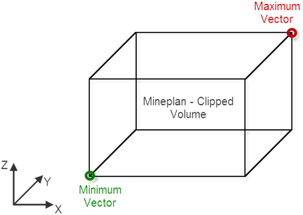
Schematic of Min and Max location Vectors in Clipping Volumes Table.
The Clipping Volumes were called “Mineplans” in v3. A table of these Clipping volumes are available in the
Home->*Mine Plans table. These v3 “Mineplans” and a "Dynamic Clipping Volume” were combined into the Table
Dynamic Clipping/Clipping Volume Table.
In order for the clipping to mine plans view option to work in the 3D viewer, the "Clipping Volumes" within the 3D view must first be configured. This can be found in
Analysis Window->Page Settings->Clipping Volumes (See figure below).
For a 3D view for which the Clipping Volumes is configured, the points and survey data can be clipped to the selected volume. Refer Analysis Window->Panel->Page Settings->Clipping Volume.

Configuring Clipping Volume in a 3D view.
Created with the Personal Edition of HelpNDoc: Create help files for the Qt Help Framework